
Assistant Professor Rajesh Veeraraghavan leads mapping exercise to assist the Government of India in its response to the COVID-19 crisis
April 8, 2020

Rajesh Veeraraghavan, an assistant professor in the Science, Technology and International Affairs program in the School of Foreign Service and member of the India Initiative Faculty Advisory Committee, worked with researcher Hridbijoy Chakraborty to use the Urban Spatial Observatory’s (USO) dataset on public services with a focus on access in informal settlements as the framework for their first COVID-19 map, published on Twitter as #DelhiHungerReliefCentre.
On 24th March at 2000 hours IST, Indian Prime Minister Narendra Modi announced a countrywide lockdown to control the Coronavirus epidemic. As India’s already significant homeless and food insecure population has exploded over the past week, the government has faced one of its most difficult and important challenges to date. As central and state governments have sought to provide free food and humanitarian support, they have faced a number of challenges, including:
- Unavailability of settlement level data in cities, where population density particularly in informal settlements is very high.
- Unavailability of public infrastructure repository and shared access to information for different departments and researchers.
Immediately after the announcement of the India-wide lockdown, we started to work on releasing data and maps for the public good. Building upon our large dataset on public services with a focus on informal settlements we published our first map with #DelhiHungerReliefCentre on Twitter.
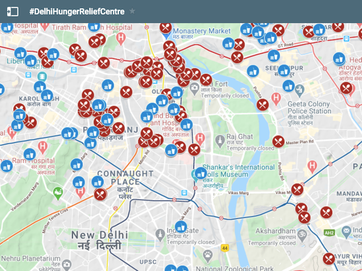
This map has the locations of all the night shelters in Delhi along with the locations of ration shops where poor people could buy groceries at subsidized rates. We also identified and mapped 427 schools functioning as Hunger Relief Centres (HRC) in Delhi. These maps are being updated regularly and shared through social media on Twitter, Whatsapp groups and through a dedicated site. The map was shared on Google’s My Maps platform, Open Street Map (OSM) and Map My India’s COVID response map.
The Delhi government subsequently decided to host our map at corona.delhi.gov.in. The Chief Minister’s Office shared the map, which was then covered in a number of news stories explaining the usage of maps in guiding people who did not have food. India Today(March 29), a national TV channel explained the map live for people to access the information. This map helped relief volunteers, social workers and government officials get access to reliable information on their mobile phones. The site was used by citizens to access information on relief centers set up by the Delhi government. As of 4th April 2020 the site had more than 300,000 views on our map.
#21DayLockdown: Delhi govt starts relief centres for those affected by the #lockdown. Customised google map launched to help find the location of relief centres. #ITVideo pic.twitter.com/vVUArPQLLP— IndiaToday (@IndiaToday) March 29, 2020
During the initial two days of the lockdown, 231 night shelters run by the government for homeless people were also serving as Hunger Relief Centers. The shelters, particularly those near inter-state bus terminus and railway stations, were quickly overcrowded with an influx of people seeking shelter. Some of the homeless were also shifting from more peripheral areas of the city towards the center for safety as the area around Old Delhi has been a safe space for homeless people. To maintain social distancing, it was necessary to decongest the night shelters in that area and we used our schools database to locate nearest schools by walking distance from such overcrowded night shelters. In coordination with the government, new Hunger Relief Centers were set up in those schools.
The Delhi government had also started a hunger helpline in each of its 11 administrative districts, to address increasing demand for food and rations. We made an internal map for use by the officers and volunteers which had one layer of active hunger relief centers and another layer of public facilities as a backup. In consultation with the Delhi Disaster Management Authority we designed a protocol to use the maps for helping people find access to relief centers. The helpline operators were trained to use the map to quickly search for the area from which they were getting requests for food, so that they could locate the nearest Hunger Relief Center and find directions to it. If a Hunger Relief Center was not available nearby, they would identify a potential Hunger Relief Center from the backup layer and flag it to their managers for approval. Throughout this process we identified and mapped 650 Hunger Relief Centers and the list continues to expand daily.
Senior officers of the Delhi Disaster Management Authority used these maps to plan and monitor the logistical operations of food distribution. Field officers, while on field duty used our maps to locate and navigate the Hunger Relief Centers in their districts. Journalists and other NGOs were also using our maps to guide homeless and hungry people to the nearest Hunger Relief Centers.
The Urban Spatial Observatory project shared some of its resources publicly in clear and accessible formats including simple dynamic maps, spreadsheets, pdf files and text messages embedded with geo coordinates to enable cross-platform accessibility. Throughout this lockdown period we plan to continue publishing updated maps and using our public services dataset to help in the fight against COVID-19.
More details at: https://www.urbanspatialobservatory.org/covid19
See also: Georgetown Researchers Support COVID Response in Delhi